History of the sea
The name of the Aral Sea stems from the word “aral”, which means an “island”. This name is associated with the fact that this vast lake lies as an island among waterless deserts of the Turan depression. In old Russian sources, it was referred to as the Blue Sea. Barthold V. V. explains that the area in the Amudarya delta used to be called “Aralan”, which means “an island between branches of a river” and believes that the name “The Sea of Aral” was derived therefrom.
The Aral Sea is located in the northern desert part of Central Asia, within the borders of Uzbekistan and Kazakhstan. Until 1960, it used to cover an area of 68 thousand square km, holding a volume of 1,000 cubic km of water.
 |
With the size, the Aral Sea ranked second in the world among endorheic inland lakes after the Caspian Sea, and was the fourth largest lake in line with the Lake Superior (Canada, USA), and Lake Victoria (Tanzania, Kenya, Uganda), therefore people called it a sea.
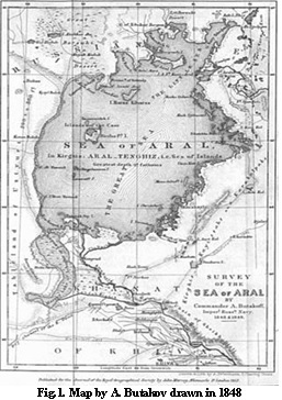
The natural elevation of the Aral Sea water surface used to be 53 meters above the sea level, which was almost 80 meters above the level of the Caspian Sea. Originally, before the shrinkage that started in 1960, it had approximately 428 km in length and 234 km in width, with a maximum depth of 69 m (elevation 53 m asl). The sea held 1,064 cubic km of water.
The northern coastline of the sea is irregular, high and low-lying, indented with deep bays, and the eastern coastline is mainly low, sandy, with many small bays and islands. The southern coastline used to be formed by the delta ofAmudarya River. Indentation of the western coastline is very moderate; it is formed by the Ustyurt chink of 180-200 m in height.
Until 1990, the sea area used to be divided into two major but unequal parts, the Large and Small Sea, connected by the Berg’s Strait.
The summer in the region is hot and long; the average July temperature ranges from 26 to 33°C. In winter, the cold air masses reach the area reducing the overall temperature. In the northern deserts, the average January temperature is -10 to -15°C, in south it may rise above 0°C in some areas. The annual precipitation ranges from 20 to 120 mm.
The water balance of the Aral Sea used to form in the following manner: the inflow was generated by 8.7 km3 of precipitation and 5.5 km3 of river runoff, with the level change of 0.6; the loss of water was mainly due to the annual evaporation of 63.8 km3 from the water surface.
The Aral Sea is a closed endorheic natural pond, but there are two largest rivers of Central Asia falling therein, the Amudarya and Syrdarya, which have always played an important role in trade and political relations between the ancients and retained their importance until present.
Amudarya received its modern name – the ancient writers called it Oaks, Oxus (Greek), Dzheyhun (Arabic) – relatively recently, in the VI century. The historians say that the name stems from the name of the city of Amul (Amus, Amuy, Amu), that used to rest on the bank of Amudarya, the present location of Turkmenabat (former Chardjou).
The length of Amudarya is 2,620 km (2,540 km according to other sources). It becomes Amudarya where the River of Vakhsh that collects water from Alay Valley and Northern Pamir conflows with the River Panj, major tributaries of which are Rivers Gunt and Bartang draining the south-eastern part of the Pamir Plateau. Its length from the point of confluence is 1,400 km.
The basin of Amudarya also includes Rivers Kafirnigan and Surhandarya running down the southern slopes of Hissar Mountains and the River Kunduz, the runoff of which generates in Afghanistan.
The overall area of the basin is 465 km2, of which runoff generation occurs only in its mountainous part (about 217 km2). The mean annual runoff ranges from 48 to 101 km3, with an average of 63 km3. The water in this river has strong turbidity of 2,500-4,000 g/m3. Strong stream bank erosion (deygish) is a common feature.
In the lower reaches, the river’s several branches used to fall into the Aral Sea, forming a delta area of about 19 km2.
Amudarya, the basin of which used to host the ancient states of Central Asia, the Khorezm (in the estuary), Sogdiana and Bactria (in its middle and upper reaches), has been known since antiquity. Currently, almost the entire runoff of the river is used for irrigation.
Syrdarya used to be named Yaksart (Greek), Seyhun (Arabic), and the locals still preserve the names of Hashart, and Tsenchyu-uguz, i.e. ‘the Pearl River’. You will not come across the modern name in the sources of even XVIII century but only of later periods, and its true origin is unknown. Syrdarya is formed by the confluence of the Naryn and Karadarya Rivers. Its length from the point of confluence is 2,206 km. The basin area is approximately 462 km2 (150 km2 of which is the mountainous part generating the runoff). The river channel is circuitous and unstable. The annual river flow fluctuates from 22 to 57 km3 with an average of 34 km3. The turbidity is high - 2,000 g/m3.
The runoff of these two rivers generates in the highlands of Tien Shan and Pamir, and comprises an average of about 110 km3 per year. But the sea, due to the natural losses in seepage and evaporation and, most importantly, due to intense diversion of river water for irrigation and watering of the adjacent desert lands, used to receive only about half of this volume, and all of the inflow would evaporate from the sea surface the same year.
Fluctuations in the level of the Aral Sea used to largely depend not only on the water sources in the whole of Central Asia, but also on the Amudarya River course direction.
According to archaeological studies, Amudarya used to alternately change its course, falling into the Aral Sea or to Sarykamysh. This was due to both natural reasons and human activities (erection of dams in V century BCE, and destruction of irrigation facilities in the times of Genghis Khan and Timur (Tamerlane).
Over the past 200 years, the Aral Sea level fluctuations have also occurred, but apparently, their amplitude never exceeded 4 m. The fluctuations in the Aral Sea level in the first half of the XX century did not exceed 1 m. In 1911-1960, the reported inflow to Aral from Amudarya and Syrdarya on average was 56 km3, and another 10 km3 used to fall on water surface as precipitation, with the average sea levels remaining constant within a narrow range of 52.2-53.4 m, mirror area of 65-67 km2, and 1,040-1,090 km3 in volume, i.e. the sea rested within the boundaries it has had 4-6 thousand years ago.
It should be noted that through the entire history of ancient irrigation in Central Asia, the water diversions from the Amudarya and Syrdarya Rivers never influenced the Aral Sea level. The amount of water consumed for irrigation throughout the basin of the sea was negligible, despite the huge areas developed at the time (in ancient times, they irrigated 3.5-3.8 million hectares, including 1.3 million hectares in the lower reaches of Amudarya, and 2.2-2.5 million hectares in the lower reaches of Syrdarya). Fluctuations in the level of the Aral Sea are likely to have been associated with the destructive internecine wars between the Central Asian states of the times, and the foreign invasions. That is when a part of Amudarya’s flow, following the destruction of artificial dams in Khorezm, swiftly escaped through the dry channels of Daudan and Daryalik to Sarykamysh.
Total number of Aral Sea islands which had a land area of 0.01 km2 and more used to comprise 1,100, before the 1961. Their total land area prior to the shrinkage was 2,230 km2. Among these, there used to be 12 major islands such as Barsakelmes, Kokaral, Lazarev, Vozrozhdeniya, etc. All of these islands were of continental origin, located along the eastern coastline. In the south of the sea, there used to be a unique Akpetkinsky (Karabayly) archipelago of more than 50 islands constituted by the waterlogged sand ridges of Kyzylkum. One of the major islands was named Barsakelmes, which translates from the Kazakh language as “if you go there, you won’t return”.
Another island with an interesting destiny was the Island Vozrozhdeniye (land area of 169.8 km2), which was discovered in the middle of the XIX century and named in honor of the Russian Tsar Nicholas. The island was one of the Royal Islands, along with the Island Constantine, named in honor of the Grand Duke Konstantin Romanov, once president of the Russian Geographical Society, and the Island Naslednik. The name Vozrozhdeniye (Renaissance) was given to it in Soviet times. For many years, this deserted island was a secret military ground to test protective equipment and remedies against biological weapons.
At the onset of drying of the Aral Sea, the first islands to merge with the mainland were the islands of Akpetkinskiy archipelago, and the bays that separated them turned into salt marshes.
The 1990 witnessed disappearance of the Kokaral Island. It merged with the mainland, and the Bay Saryshyganak ceased to exist. The Berg’s Strait followed them along and disappeared. The land areas of other islands began to expand. In 10 years, all the islands merged together and into the mainland, dividing the Big Sea in two – the Western and the Eastern Sea.
The Aral Sea used to be surrounded with a rich and diverse nature that had its own unique life.